For many years I've stopped on rides to pick up lost items on the side of the road. I've found calendar organizers, checkbooks, about $140 in cash, thirteen working mobile phones (four returned), a policeman's badge, over 1000 individual tools (including enough sockets to make up a complete US and metric set), and dozens of tie-down straps. Around 2008 I began noticing women's undergarments on the roadside. This post is a collection of photographs that document the condition and locations. I have never brought any of these home, though I have poked several with sticks.
 |
| Leading the charge with our banner! |
Observations
- Early in the count, I didn't track men's undergarments. In 2022, I spotted more pairs of boxers and briefs than thongs and panties.
- Initially, the sightings clustered outside the summer months, even though the total miles I ride is probably higher in the summer, which would lead to more frequent sightings. Over time the distribution has become more uniform.
- Bra sightings have increased (though they are still uncommon) since 2018.
- 2018 was the new International Year of the Road Thong, but..
- 2019 outstripped all previous years by a large margin!
- 2023 blows all of them away.
- I rode fewer miles in 2020 to 2022, so there was less opportunity for sightings.
- 2023 shows that we're out of the pandemic!
Note: plot updated through 2025-03-20!
The collection
- A google map that shows the locations and dates of the sightings follows the image collection.
- A full size map is here Thong Map
- A collection of other photographs submitted by the members of the Cooperative Road Thong Network is here.
The Images
 |
| 2025-03-20 #151 Backlick Rd under the 495 overpass. Victoria's Secret brand. GPS: |
38.7946, -77.1862
 |
| 2025-03-17 #150, Gallows Road Near Tyson Oaks Circle. Maidenform brand--like a spanx. GPS 38.9063, -77.2223 |
 |
| 2025-03-11 #149 On River Rd near Esworthy, very near #143 and #147. GPS: 39.063669 -77.290813 |
 |
| 2025-03-04 #148 Tommy Hilfiger brand. in front of Way of Faith church on the Rt 50 service road east of Barkley Gate. GPS: 38.865616, -77.250473 |
| | |
2025-02-26 #147 No brand or size info. Almost directly across the road from #143, also spotted on a ride with Tim and Rob two months before.
 |
| 2025-02-22 #146 Victoria's Secret/Pink Size M. Sunrise Valley @ Glade Rd. GPS: 38.948344, -77.375008 |
 |
| 2025-02-16 #145 IFG Size XL. GPS: 38.967608-77.272353 9422 Brian Jac Ln. |
 |
| 2025-02-15 #144 Prosperity Ave N of Rt 50. No manufacturer info. GPS: 38.867297-77.239389 |
 |
| 2024-12-30 #143 Road Bra! River Rd Near Esworthy. 2nd road bra of 2024. GPS: 39.063658, -77.289575 |
 |
| 2024-10-26 #142 Ethika brand workout shorts (a bit nasty on the inside). Porter County 200W at C Damon Creek GPS: 41.559792, -87.104919 |
 |
| 2024-10-03 #140 and #141. Atlantic Blvd in Dulles . Reebok. GPS: 39.022361 -77.424736 |
 |
| 2024-08-02 #139 Idylwood @ Shreve Hill. No brand info . GPS: 38.89271525655122, -77.22005486988537 |
 |
| 2024-06-25 #138 Herndon Parkway N of Summerfield. Pink brand, Size M. Almost directly across the street from #135. GPS: 38.971369, -77.406456 |
 |
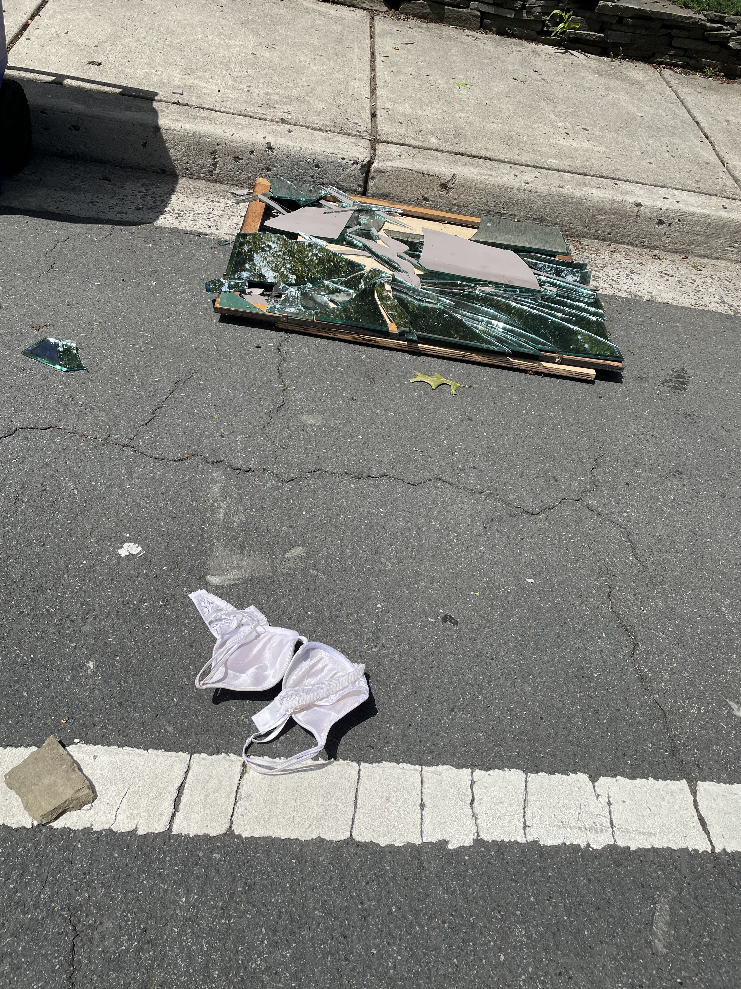
| 2024-05-29 #137 2546 Military Rd, Arlington. Weird tableau with road bra and shattered mirror. Bra sighting number six of all time. GPS: 38.90486, -77.10909 |
 |
| 2024-04-21 #136. Prosperity Rd, Fairfax. Single lacy stocking. |
 |
| 2024-04-20 #135 Herndon Parkway north of Summerfield. No brand information. GPS: 38.971522, -77.406175 |
 |
| 2024-03-26 #134 Five Oaks @ Blake Lane Vienna. Fruit of the Loom and pretty nasty. GPS: 38.8738, -77.2814 |
 |
| 2024-03-17 #133 Bull Run Postoffice Rd, near Naylor, in a sad tableau of Christmas decorations and furniture all dumped by the side of the road. GPS: 38.823178, -77.486722 |
 |
| 2024-02-26 #132 Campbell St @ Grove St, Valparaiso, In. I was on a walk because my back hurt so much. GPS: 41.475447, -87.065833 |
 |
| 2024-02-14 #131 Old State Rd 2 in Porter County, Indiana. GPS: 41.508861 -86.950856 |
 |
| 2024-01-08 #130. Ravensworth at Little River Turnpike. Ravensworth at Little River. I had missed the light so I got up on the sidewalk to get out of the left turn lane and spotted it. GPS: 38.83043,−77.196713 |
 |
| 2024-01-08 #129 Ravensworth Rd @ Heritage. When I doubled back to check it out (I thought it was a bandana because it was next to two gloves, I found $0.36. GPS: 38.815693,−77.207244 |
 |
| 2024-01-08 #128 Guinea Rd @ Burnetta Rhonda Shear brand. Plus some other lingerie. GPS: 38.81517,−77.265664 |
2023-12-31 #127 Glade Rd, Reston Pink brand. GPS: 38.932128,−77.358069
 |
| 2023-12-11 #126 New Orleans airport, American Airlines check-in. Despite three days of wandering the decadent French Quarter, it was the airport that delivered. |
 |
| 2023-11-27 #125 Braddock Rd (N side) at Accotink Creek. Size XXXL, but no manufacturer information. |
 |
| 2023-11-25 #124 Porter St, Merrifield. About 20 m N of #123. Pink brand. |
 |
| 2023-11-25 #123 Porter St, Merrifield. Manufacturer info not captured |
 |
| 2023-10-11 #122 Cedar Lane, Vienna. Size S |
 |
| 2023-09-21 #121 Hummer Rd @ Marshall, Annandale. Size 5XL "Expressions." |
 |
| 2023-09-11 #120 Wakefield Chapel N of Glen Park Rd, Annadale. Lace-trimmed sports bra. No manufacturer information |
 |
| 2023-08-23 #119 Near 938 Vermont Rt 114 in East Haven Vt. |
2023-07-09 #115 through #118. About 300 yards south of #111 through #114 on Prosperity Rd. The long sightlines made it possible to safely record them in their native habitat. It appears that someone had a laundry day disaster!
2023-07-09 #111 through #114, on Prosperity Rd. I admit that I restaged this shot in the interest of safety after moving them from the centerline, because they were on a blind turn.
2023-07-01 #110 near the top of Coxey Brown Rd, just before Gambrill Park Rd. I was going about 4 mph at 45 rpm, but still looped back to get the shot.
2023-05-24 #109 Uncommon sports-bra sighting. Guinea Rd down the hill and N of Braddock.
2023-05-24 #108 Festive color. Guinea Rd down the hill and N of Braddock
2023-04-06 #107. Only counting this one as a single, even though at least four are in the shot. The sad tableaux included some kids clothing and an abandoned car seat, obviously all dumped from a vehicle. River Rd W of Partnership Rd.
2023-03-30 #106. It's pretty big. Annandale Rd, Falls Church
2023-03-23 #104 and #105 XXXXL (that's a lot of Xs!) negligee set Prosperity Rd S of Rt 50.
2023-03-05 #103 Maidenform size M at Guinea Rd @ ElJames
2023-01-28 #102 on Lime Kiln Rd, near Oatlands plantation.
 |
| 2023-01-11 #101 4600 block Backlick Rd, Springfield |
2022-09-22 #100 Muddy Branch at Great Seneca Highway
2022-07-26 #99 Campbell Rd, Valparaiso, Indiana
2022-07-26 # 98 250@ in Valparaiso, In, near the 3-way railroad crossing. First of a two-in-one-ride day.
2022-03-14 #97 Sunrise Valley Reston
2022-02-21 #96 relatively rare bra top
2022-01-31 #95 4812 Ravensworth Rd, Annadale, VA
2021-09-15 #94 Edsall Rd near Cather St. Also found a tumbleweave just around the corner: GPS: 38.8070944 -77.1785306
2021-08-23 #93 Pimmit Hills GPS: 38.91610299 -77.19483097
2021-08-11 #92 On my "there's no power at home" walk. GPS: 38.89565853131864, -77.19210890891235
2021-07-04 #91 On my way from the liquor store to the Giant for 7/4 supplies. Had to dodge some traffic, so the photo and data quality suffered. GPS: 38.89565853131864, -77.19210890891235
2021-06-07 #90 Cooley Rd Parksville, NY Catskills Bike Trip. GPS: 41.858705, -74.75565
2021-04-20 #89 Gap body brand, W&OD path Falls Church. GPS: 38.89094326, -77.1799278
2021-02-25 #88 Braddock Rd W of Wakefield Park GPS: 38.81151, -77.22555
2021-01-13 #87 Woodfield School Rd GPS 39.2575, -77.18792
2021-01-13 #86 Woodfield School Rd GPS 39.2564083, -77.1892778
2020-12-12 #85 Van Buren St W of Dulles Toll Rd, Victoria's Secret GPS: 38.9492833,-77.3914111
2020-111-21 #84 Sam Fred Rd, Middleburg. GPS: 38.97800013, -77.72195283
2020-10-03 #83 Montevideo Rd, Montgomery County GPS: 39.08712, -77.34551

2020-09-15 #82 Rt 115 Mountain Mission, WV. GPS not recorded. On my ride back from the gravel tour shakedown mini-trip.
2020-08-27 #81 Game Preserve Rd, Gaithersburg, Md. GPS: 39.16147, -77.23074
#80 2020-08-19 Charles St, near Rt 7 Seven Corners. GPS: 38.852086 -77.136529
#79 2020-06-01 Fairview park over Rt 50 GPS: 38.86602 -77.213626
 |
| 2020-05-18 #78. Pink brand. Size indeterminate. Westbranch @ Westpark, Tysons Corner. GPS: 38.92663, -77.22228 (corrected from image header) |
 |
| 2020-04-19 #77 Man's "banana hammock" Manufacturer indeterminate. Odricks Corner (Springhill Rd @ Turning Leaf). GPS: 38.9360083 -77.2316222 |
 |
| 2020-04-12 #76 Corona Virus edition #3 of three in one day! Victoria's Secret size 34B. Shreve Rd near Pioneer Lane. GPS: 38.8816889 -77.2198778 |
 |
| 2020-04-12 #75 Corona Virus edition #2 of three in one day! Indeterminate brand and size (too faded) Braddock Rd near Inverchapel Rd. GPS: 38.811625 -77.22705 |
 |
| 2020-04-12 #74 Corona virus edition #1 of three in one day! Indeterminate brand and size. Rt 7 near Carlyn Springs GPS: 38.8599333 -77.1469139 |
 |
| 2020-02-09 #71 Felina Brand, size M. Atlantic Blvd, Dulles |
 |
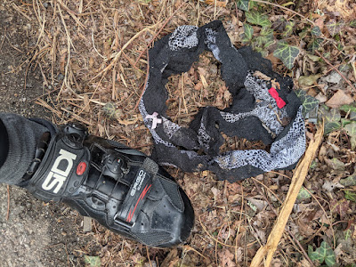
| 2020-01-25: Doc Johnson brand silicone dildo. Reston. 38.93299 -77.358844 Interestingly, almost exactly two years from the previous sex-toy sighting. |
 |
| #70 2020-01-22 Gallows Rd Size S/M Calvin Klein; GPS: 38.9103056 -77.2233194 |
 |
| #69 2019-12-28 Great Falls St @ Hutchison; Size M Victoria's Secret Dream Angels GPS: 38.905675 -77.181925 |
 |
| #68 2019-12-18 Travilah, just north of Glen. Size L "Man Power" sexy man's jockstrap. this is the first ornamental man's undergarment I've ever found. GPS: 39.071166, -77.260828 |
 |
| #67 2019-11-26 Georgetown Pike at Old Dominion. Size S Victoria's Secret. GPS: 38.9818083, -77.25715 |
 |
| #66 2019-10-06 Pioneer Apartments, Valparaiso. Coming home from Fluid Coffee. GPS: 41.4698778 -87.0595833 |
 |
| #65 2019-07-23 Millenium Park Valparaiso. While getting coffee on the way to Intelligentsia Cup. GPS: 41.467458, -87.063594 |
 |
| #64 Persimmon Tree north of MacArthur. Too destroyed for any information. GPS: 38.9763889,-77.1691667 |
 |
| #63 2019-06-26 River Rd near Muddy Branch. Only spotted it when I circled around to check out a possible road tool. "Art Class" (A Target swimsuit line) Size 14/16. GPS: 39.0630556, -77.2958333 |
 |
| #62 2019-06-22 Hunter Mill just south of Crowell at the Reston Presbyterian Church. Worse for the wear, after passage through a lawnmower. GPS: 38.9517083 -77.311925 |
 |
| #61 Whole Foods Tysons parking lot on the way to lunch. Was originally wrapped in the sandwich wrapper. Aerie brand (American Eagle). No size info--someone said "Quit poking at that." |
 |
| #60 2019-04-02 On Rt 28 at the intersection with Norman Dr. Marilyn Monroe Brand, size M. Coincidence? Marilyn was married to Norman Mailer at one point... GPS 39.1154944,-77.2649278. |
 |
#5 9 2019-03-24 On Alt 40 near the summit. Some kind of onesy.
GPS: 39.4778861, -77.6102444 |
 |
| #58 2019-03-20, while riding over to Tom S' to pick up some emergency tubes for the ride home on 28 near Riffleford. Took me a long time to figure out what it was--kind of a camisole/underwear lingerie. GPS: 39.1182389 -77.2596806 |
 |
| #57, near Rogers Lakewood Pk, on Meridian Rd. Victoria's Secret Brand. GPS: 41.5190056 -87.0658611 |
 |
| #56 2019-03-02 On the way home from the PoCo Historical society museum on Monroe near College: Pink brand. GPS: 41.4657722, -87.0541806 |
 |
| #55 2019-03-02 Locust (?) just S of Lincolnway in Valpo, while Mark and I were walking to the PoCo Historical Society. Pretty big, no manufacturer info. GPS: 41.467619 -87.053811 |
 |
| #54 2019-02-28 700N Valparaiso, just east of Camp Lawrence. GPS: 41.535215 -87.046592 |
 |
| #53 2019-02-24 on the Whites Ferry Ride on Elmer School Rd, with my magic charm, Michelle N. GPS: 39.14688 -77.483633 (approximate--no exif tag in image) |
 |
| #52 |
 |
| #51 2019-01-08 Algonkian Parkway near Lowes Island Blvd. Double sighting. One Hanes brand. One unbranded. Very large. |
 |
| # 50 2019-01-04 Lawyers Rd at Kedge Dr. No brand or size info. Kind of dangerous getting the photo. GPS: 38.909567, -77.284726 |
 |
| 2018-12-28 Calumet Rd North of Bullseye Lake Rd, Valparaiso, IN. It was still there when I rode by on 2019-03-02 |
 |
| 2018-12-13, Piney Meetinghouse Rd. "Pink" brand. No size info. GPS 39.0647694,-77.2291056 |
 |
| 2018-10-15 Quince Orchard Rd just south of the NIST C gate. Had to circle back around and stop for light. No manufacturer or size information. Quince Orchard is a busy, stick-free road. GPS coordinates: 39.1351667, -77.2234083 |
 |
| 2018-08-30, Schaeffer Rd, just south of the soccerplex roundabout. "Just Be" brand in size 8/XL |
 |
| 2018-08-16, Seneca Rd south of MD Rt 28. No manufacturer information. |
 |
| 2018-08-12 Algonkian Parkway just west of the Sugarland Run bridge, Sterling. While bunnyhopping the median to check out a possible sighting from the day before, I found this one right under my front wheel. Warner Brand, size info was worn off. |
 |
| 2018-07-22. Corner of West and Broad St, Falls Church, while walking back from getting coffee. Tag cut out--no size or manufacturer information. Who knows how far it drifted during yesterday's flash-flood. |
 |
| 2018-06-10. Marshall, VA Park-n-Ride, after an absolutely delightful 60 miles of gravel. Size XS, no manufacturer information. |
 |
| 2018-05-15. Assignment is tentative. I struggled to decide if this was just a re-sighting of the 9/28/17 thong. But I went back to confirm manufacturer information on 2018-05-30 and found no label. Also I almost missed finding it, because it was so buried and filthy. I do not believe that it could have survived the entire winter and stayed in the condition I saw it on 2018-05-15, given the degradation that occurred in only two weeks between sighting and verification. |
 |
| 2018-03-27 while riding to work, on Stonebridge Dr, North Potomac. A pretty big pair of Hanes Comfortsoft. If it's from the Walk of Shame, it was a pretty shameful evening... |
 |
| 2018-03-06, Marshall, VA. Another tentative sighting--really more of a"loungewear/pajama bottom" Second sighting in a row on a ride with Michelle N. |
 |
| 2018-01-27 On Business Rt 15 in Leesburg, VA. The expressions of the people driving by as I was photographing were priceless. Just couldn't pass it up, even though it's slightly off-topic. |
 |
| 2017-12-19. Old Calumet Ave just south of US 6, Valparaiso, In. Cacique brand (A Lane Bryant marque, which explains the size). |
 |
| 2017-11-27. Seneca Rd. No manufacturer or size info, but kind of Christmassy--those are tiny reindeer. GPS: 39.081, -77.318. Found later in the ride after heading out Riffle Ford to try to self-spot the Friday CRTN sighting by Rob Laybourn. Also found and returned an iPhone today. |
 |
| 2017-10-19 Ed Garvey Memorial Shelter, Appalachian Trail (sports bra) |
 |
| 2017-09-28. Schaeffer Rd at Little Seneca Creek. "Best fitting panty" (a Walmart brand) in size 2XL9. Tom Snyder photo credit. |
 |
| 2017-08-16 Quince Orchard by NIST C gate. Does it really count?--It's really more of sports-bra top. No manufacturer information |
 |
| 2017-08-10 MD 28 @ Riffleford. I had stopped to pick up a penny in the intersection, and Colleen spotted it. No manufacturer or size information. |
 |
| 2017-06-13. S Glen Road near the one-lane bridge. No size or brand data--looks to have been lawn-mowed. |
 |
| 2017-04-05 Query Mill Rd, Darnestown on our lunch ride. No size or manufacturer information. |
 |
| 2017-04-01. Reddish Knob, Va Elevation 4397' 11:37AM. I admit that I scouted the parking lot, because I knew that this was a "romantic" location. Fruit of the Loom, size 5. Early in our epic 100 mile day. |
 |
| 2016-11-26. After a false alarm yesterday when I spotted what looked like a winner, but turned out to be from "Baby Gap," I spotted this one today under a car at the parking lot at the local Giant. No data on sizes or makes, for obvious reasons. |
 |
| 2016-08-21. On my way to Starbucks, behind the Indian Spices store adjacent to the W&OD path. Some kind of bizarre name, like "Modern Confluence." Super clean. |
 |
| 2016-05-21 Sharp Park on Williamsburg in Arlington, VA. Had to get all "CSI Arlington" to even partially identify. The victim seems to have had an unfortunate interaction with a lawnmower. I immediately instituted a grid search of the area, and located two more parts, but neither of them had any identifying label. Assignment is not 100% certain due to damage. |
 |
| 2016-03-21 (First day of Spring!) a "Best Fitting Panty" (A Walmart brand) in size L/7. Just outside the NIST C-gate. |
 |
| 2016-1-15 on Burdette Lane adjacent to the South Germantown Soccerplex. A "Steve" brand (Nordstrom?) in size XL |
 |
| 2015-12-24. From some kind of "Sexy Holly Hobby" outfit. Washington Blvd in Arlington S&L brand, size 14. |
 |
| 2015-12-22 Christmas Miracle Edition. Warner Size 6 (M) on Old Bucklodge Rd in Boyds, MD. |
 |
| 2015-10-06 at the NIST main gate |
Terrible picture, but my phone died after shooting one image. On Clopper Rd at the NIST main gate. Labels were too worn to identify the model. Then it got caught on my shoe when I went to ride away.
 |
| 2015-08-11 Sunday in NW Indiana just north of US Rt 6 on 200W. Looks like it had an unfortunate interaction with a lawnmower. |
 |
| 2015-07-12 CVS @ Falls Plaza getting coffee with Sandra |
I went for coffee with Sandra on her last day as a woman of leisure. We walked to the ATM to get money, and there it was!
 |
| 2015-06-08 Quince Orchard Rd south of QOHS |
Led there by Tom Snyder (again!) who spotted on his way to our lunch ride. The most "buttflossy" of all the sightings. No brand information.
 |
| 2015-05-11 Bucklodge Rd with Tom Snyder. No logo. |
Tag says "Remove B4Uplay" but doesn't have any brand information. It's really probably a swimsuit bottom or that garment that cheerleaders wear under their skirts.
 |
| 2015-03-24. Quince Orchard Rd, Gaithersburg, near the NIST "C" gate. |
Xhileration brand (apparently another Target house brand). I didn't have my phone with me, so I had to go back later in the car after securing the item with a rock to keep it from blowing away. I was certain that the NIST police would swoop down on me while I was standing next to the fence photographing something.
 |
| 2015-03-03 White Ground Rd, Boyds Md |
H&M black thong, European size 36. Spotted on a miserable day with ice pellets raining down on us. A fine reward to complement my feeling that I was a Belgian hardman. Almost a year to the day after the "first day of meteorological spring" sighting in 2014!
 |
| 2015-02-11. Spring Meadows Drive Darnestown Md |
More data! A Gilligan and O'Malley Intimates. (This appears to be the Target house brand.). Actually taken there by Tom Snyder, who had spotted it on his ride earlier in the week. Only about 250m from the 2015-01-19 monster-bra sighting, though this one is much too small to be from the same person.
Conversation during the documentation:
Me: "Hey, I need a stick!"
TKS: "Of course you do..."
 |
| 2015-01-19 Special Sugarloaf ride, MLK-Day Giant Bra sighting. Didn't have the proper tools to determine the size, but it looked biiiig. First photo with the new GoPro. |
 |
| 2014-12-21 Christmas miracle. On the NCVC ride on Bradley Blvd near Hillsmead. Luckily I caught back on at the regrouping point. |
2014-09-03. Completely fortuitous. After dropping Tom off from our noon ride, I circled back to check out a North Face bag in the gutter. This jaunty pair was next to it--didn't notice it all on the first pass.
2014-08-14. Spotted while riding home from work. Actually saw a pair of (very rare) boxer shorts later on River Rd. Kind of made up for having my phone eject from my backpack and get destroyed while riding to work. And then I found a combination 12mm/14mm box wrench a little later in the ride. Interesting coincidence with the 2014-03-01 sighting.
 |
| 2014-05-25 Ballston, (Arlington) Virginia |
2014-05-25. Sighted while picking up Tom Godfrey on our way to the MABRA criterium championships. As I was loading his bike, Tom mentioned "check out my sidewalk--it's an omen!" And it was a very good omen. Tom was 2nd and I got the last paying place. Some have pointed out that it's not technically a thong, of course.
2014-04-18. During my spring bike trip in the middle of the road just after the bridge over the Dry Fork in Jenningston, WV. This sighting was almost exactly a year after the Spring Trip 2013 WV sighting in Dolly Sods (below) . This incident represents the second WV occurrence.

2014-03-01. Discovered on a solo ride out to Sugarloaf and back from NIST. Because I had stopped to photograph the view from the summit, my phone died when I took the first thong picture. I drove back out to the site, parked in a driveway, ran up the road, and repeated the photograph. Technically not a "winter" sighting: March 1 is the first day of "meteorological spring." On the same ride I also found a nickel and a 7/16" 1/4-inch drive socket. Score!
link:
Google Map Location
2013-12-18 on Muddy Branch by the sewage dumping station. Really more of workout/sporty underwear. Very clean!
2013-10-01 near 18600 River Rd in Poolesville, Md On our post-furlough mid-day ride. Not technically a thong, of course.
 |
| 2013-04-13. On FR 75 in the Dolly Sods Wilderness at elevation 4000' Actually discovered by Jim Keenihan at the end of our lunch stop. Label states "Tuesday." Weirdly, I had stopped about 1/2 way up the climb for another possibility, which turned out to be only a lacy workout top. |
 |
| 2013-03-05 on the W&OD path near the Italian Store. I almost missed the Tuesday ride because I stopped for photo-documentation. |
 |
| 2012-12-10 On Muddy Branch. in Gaithersburg. Slightly out of focus because I had to run into the road to photograph it. Also, not technically a "thong" but more of a "boy short." |
 |
| 2012-11-01 on Quince Orchard adjacent to the NIST campus. |
 |
| 2012-02-20 on Howellsville Rd near Front Royal , Va. Photographed while on a solo tour of the Blue Ridger Ride It was an awfully cold day for flinging undergarments. |
 |
| 2010-11-13 on Quince Orchard Rd south of Great Seneca Highway. The motherlode. One of the few bra sightings. |
Sightings without photodocumentation
I was not careful about backing up my old phone (a Treo 700), and I deleted the pre-2009 images by accident.
- 2009: Corner of Offutt and Mount Nebo in Poolesville, Md. Two thongs spotted during a recon of the Poolesville Road Race course. Probably the original sighting that triggered this collection.
Geo-tagged locations
The map below documents the locations of each sighting. You may need to zoom out to locate all the locations.
View Thong Map in a larger map
Other road-side collections of personal products
Below are some links to even more horrific road-side sightings of intimate products.